Climbing Jebel Zaghouan
Is Jebel Zaghouan a good hike for a visitor based in Tunis?
Yes, with reservations. The mountain sits about an hour south of Tunis and offers a genuine, moderately strenuous hike with real views over Cap Bon and the Gulf of Tunis, but the marked trail is inconsistent, shade is limited, and the reward is more about the setting than any single dramatic feature at the top. It suits travellers who want an active day rather than a passive sightseeing stop, and who are comfortable navigating a route that isn't always clearly signed.
Jebel Zaghouan rises to 1,295 metres above the town of the same name, about 60 km south of Tunis, and it’s the closest thing the Tunis region has to a proper mountain hike. At its base sits the Temple of the Waters, a Roman nymphaeum built to mark the spring that once fed the 132 km aqueduct to Carthage, and from there a trail climbs through pine and scrub toward a ridge with views stretching over Cap Bon and, on a clear day, out to the Gulf of Tunis. It isn’t a technical climb, but it isn’t a stroll either: the path is uneven, only partly marked, and the last stretch to the summit involves genuine scrambling over loose rock.
This is a hike for travellers who want something more active than a Roman ruin or a medina walk, and who don’t mind a route that requires some judgment rather than following a clearly signposted trail from start to finish.
| Where | Jebel Zaghouan, above Zaghouan town, about 60 km south of Tunis |
| Cost | Free to hike; small entry fee at the Temple of the Waters, around 5 TND (roughly €1.50) |
| Time needed | 4 to 6 hours round trip to the summit; half a day minimum from Tunis |
| Getting there | Car hire (about 1 hour from Tunis) or an organised tour that includes Zaghouan |
| Best time | Early morning, spring or autumn; avoid midday in summer |
The mountain above the Roman aqueduct’s source
Jebel Zaghouan owes its place in Tunisian history to water, not to the mountain itself. The springs at its base were the most reliable source in the region, and in the second century AD the Romans built a 132 km aqueduct, one of the longest in the Roman world, to carry that water to Carthage.
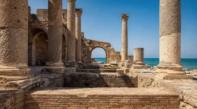
The structure the Romans built to monumentalise the spring, known today as the Temple of the Waters, still stands at the foot of the mountain: a semicircular nymphaeum with a colonnaded courtyard, niches that once held statues, and channels that fed the aqueduct’s opening arches. It’s a smaller, quieter site than Carthage’s Antonine baths, but it’s the point where the aqueduct’s whole 132 km run actually begins, which gives it a context that’s easy to miss without knowing the backstory.
The mountain above the temple was, for centuries, treated mostly as a backdrop. It’s only in more recent decades that it has been developed as a hiking destination, with a rough trail network maintained loosely by local guides and the occasional hiking club rather than a national park authority. That informality is part of the experience and part of the challenge: this isn’t a groomed trail with distance markers and rest stops, and visitors used to more developed hiking infrastructure elsewhere should adjust their expectations before setting out.
The town of Zaghouan and where the trail begins
Zaghouan town itself is a modest, workaday place, with a small medina, a handful of cafés around the main square, and none of the tourist infrastructure found in Sidi Bou Said or Hammamet. Most hikers pass through quickly on the way to the trailhead near the Temple of the Waters, on the edge of town, though the medina is worth a short look if time allows: narrow streets climbing the lower slope of the mountain, a modest central mosque, and views back down over the plain that give a sense of why the Romans valued the site’s elevated, defensible position.
The trailhead itself is a short walk uphill from the temple, past a small forestry building that sometimes has informal information about current trail conditions. There’s no formal visitor centre, so anyone planning the hike is better off checking conditions with a guide or a tour operator in advance rather than assuming facilities will be available on site.
The trail to the summit
The route to the summit of Jebel Zaghouan is roughly 5 to 6 km each way, gaining close to 900 metres in elevation from the base near the Temple of the Waters. The lower third winds through pine forest and scrubby maquis, with a reasonably clear path and some shade, which makes it the most forgiving section. The middle section opens onto exposed slopes with looser footing and little shade, and the final approach to the ridge involves scrambling over rock outcrops that require hands as well as feet in a few short stretches.
Trail markings are inconsistent: cairns and old paint marks exist in places, faded or absent in others, and it’s common for hikers to lose the main path briefly on the upper slopes. This isn’t a mountain where getting seriously lost is likely, since the summit ridge is visible for much of the climb and serves as a natural point of reference, but it does mean the hike suits people comfortable with some route-finding rather than those expecting a fully signed trail throughout.
The summit ridge and what you’ll actually see
The summit itself is a rocky ridge rather than a single dramatic peak, topped by a small disused structure and, on clear days, views that reach across Cap Bon toward the coast and, in the other direction, over the interior toward Zaghouan’s agricultural plain. Haze is common, particularly in summer, and it can significantly reduce visibility, so the clearest views tend to come on cooler, drier days in spring or autumn rather than during the hottest months. It’s worth being honest that the summit isn’t a spectacular single feature the way, say, a coastal viewpoint might be; the reward here is the physical experience of the climb and the sense of scale over the surrounding landscape, more than any one photogenic vista at the top.
How difficult is the climb, really
Framed honestly, this is a moderately strenuous hike rather than a serious mountaineering outing, but it’s more demanding than most visitors expect from a “day trip near Tunis.” The elevation gain is substantial for a single push, the terrain underfoot is loose and uneven for long stretches, and there’s minimal shade above the treeline. A reasonable level of fitness and prior hiking experience make a meaningful difference to how enjoyable the day is; this isn’t a route for a first-ever hike or for young children.
Guided groups typically budget four to six hours for the round trip, including breaks, though fit and experienced hikers moving at a steady pace can sometimes complete it faster. Anyone unsure of their fitness should plan for the longer end of that range and set a turnaround time in advance, since descending the loose upper sections in fading light adds real risk that’s easy to underestimate when the ascent has gone well.
What to bring and when to go
Sturdy hiking boots with good ankle support and grip matter more here than at most Tunisian sites, given the loose rock and scrambling sections near the summit. At least 1.5 to 2 litres of water per person is sensible, since there are no refill points once past the base, and a hat, sun protection and layers for the exposed ridge are all worth packing regardless of season. Starting early, ideally at or before sunrise in summer, avoids both the worst heat and the haze that tends to build over the course of the day.
| Item | Why it matters |
|---|---|
| Hiking boots | Loose rock and scrambling on the upper slopes |
| 1.5–2 litres water per person | No refill points above the base |
| Hat and sun protection | Little shade above the treeline |
| Early start | Avoids midday heat and afternoon haze |
| Offline map or GPS track | Trail markings are inconsistent in places |
Zaghouan as a day trip from Tunis
Zaghouan sits close enough to Tunis, roughly an hour by car, that it works well as a standalone half-day or full-day excursion rather than requiring an overnight stay. Self-drive visitors can combine the hike with a look at the Temple of the Waters and a brief stop in the town itself, while those without a car generally join it as part of a wider tour through the region, since public transport to the trailhead specifically is impractical.
A two-day tour of northern Tunisia that includes Zaghouan pairs the mountain with other stops across the region for travellers who’d rather not organise the logistics of a standalone hiking day themselves, particularly useful for anyone without their own transport.
For context on other options in the same general direction, the Cap Bon hiking trails guide covers gentler routes closer to the coast, and the water temple of Zaghouan and the Roman aqueduct guide focuses specifically on the archaeological site at the base for visitors who want the history without the climb.
Combining Zaghouan with the Roman sites of the interior
Because Zaghouan lies on the route between Tunis and several inland Roman sites, many day trips combine the mountain, or at least the Temple of the Waters, with stops at Oudhna, Thuburbo Majus or further afield toward Kairouan and El Jem.
A private day trip to Kairouan and El Jem, with an optional stop in Monastir, doesn’t include the hike itself but passes through the same general region and suits travellers who’d rather see the Roman amphitheatre at El Jem and Kairouan’s medina than commit a full day to climbing. The El Djem amphitheatre guide and the Kairouan holy city guide cover those stops in more depth.
Travellers who’d prefer to pair the mountain with a coastal day instead might look at a day trip from Tunis to Hammamet and Nabeul, which trades the hike for beaches and Nabeul’s pottery workshops, useful as an alternative for anyone travelling with people who’d rather not climb. The Nabeul pottery and ceramics guide has more on that side of the trip.
Guided versus self-drive options
Self-driving to Zaghouan is straightforward for anyone comfortable with Tunisian roads: the drive from Tunis takes about an hour via the A1 motorway, and parking near the Temple of the Waters is informal but generally available. The advantage of driving yourself is flexibility, particularly around start time, which matters given how much difference an early departure makes to heat and visibility on the summit.
Guided options remove the need to navigate the trail’s inconsistent markings and provide a local point of reference if conditions change, which is a genuine advantage for less experienced hikers. The trade-off is a fixed schedule and, on multi-stop tours, less time actually spent on the mountain itself relative to time spent travelling to and from other included stops. Travellers weighing this trade-off more broadly may find the private versus group tours in Tunisia guide useful.
Comparing Zaghouan to other outdoor options near Tunis
| Option | Distance from Tunis | Character |
|---|---|---|
| Jebel Zaghouan | About 60 km, 1 hour | Moderate mountain hike, real elevation gain, exposed ridge |
| Cap Bon trails | 70–100 km, 1.5–2 hours | Gentler coastal and hill walking, more shade |
| Aïn Draham forests | About 150 km, 2.5 hours | Cooler, wooded hiking in the Kroumirie mountains |
| Cycling around Tunis | Within the city and bay | Flat, low-effort, no elevation gain |
The Aïn Draham and the Kroumirie forests guide is worth a look for travellers who want a genuinely different, cooler hiking environment further north, while the cycling around Tunis and the bay guide covers a much lower-effort alternative for the same general region.
When to visit
Spring and autumn offer the most comfortable conditions, with cooler temperatures and generally clearer visibility from the summit than the haze that tends to build during summer. Winter is a reasonable option too, since Zaghouan rarely sees severe cold, though rain can make the upper rock sections slippery and should be taken seriously given the scrambling involved. Summer hiking is possible but demanding, and it should only be attempted with an early start, ideally beginning before or around sunrise to be off the exposed upper slopes before the heat peaks. General seasonal context for the wider region is in the best time to visit Tunis guide and the best time tool.
Frequently asked questions about climbing Jebel Zaghouan
How long does the hike actually take?
Budget four to six hours round trip for most fitness levels, including rest breaks at the summit. Fast, experienced hikers can sometimes do it in three to four hours, but it’s sensible to plan for the longer end, particularly on a first attempt when the terrain and route-finding are unfamiliar.
Do I need a guide?
Not strictly, but a guide reduces the chance of losing the trail on the upper slopes and can make useful calls about turning back if conditions change. Less experienced hikers, or anyone unfamiliar with reading terrain without consistent markers, will get real value from going with a guide or a small organised group rather than attempting it solo.
Is the hike suitable for children?
Generally not recommended for young children, given the elevation gain, exposed terrain and scrambling near the summit. Older, fit teenagers with hiking experience can usually manage it, but this isn’t a family day out in the way a beach or a museum visit would be.
What’s at the actual summit?
A rocky ridge with the remains of a small disused structure and views over Cap Bon and, conditions permitting, toward the coast. It’s not a single dramatic peak or feature; the experience is more about the climb and the overall vantage than any one photogenic point at the top.
Can I visit just the Temple of the Waters without hiking?
Yes, and many visitors do exactly that. The temple sits at the base of the mountain and can be seen in 30 to 45 minutes without attempting the climb, which makes it a reasonable option for travellers who want the historical context without the physical commitment.
Is there anywhere to eat or refill water near the trail?
No, not once past the base. A handful of cafés exist in Zaghouan town itself, useful before or after the hike, but there’s nothing along the trail, so all food and water needs to be carried in.
How does Zaghouan compare to hiking in Aïn Draham?
Zaghouan is a single mountain with a defined summit push, hot and exposed for much of its length; Aïn Draham, in the Kroumirie mountains further north, offers cooler, more wooded hiking across a broader area with more shade. Travellers who find heat and exposure off-putting may prefer Aïn Draham, while those wanting a clear single-day summit goal will likely prefer Zaghouan.
Is it possible to combine the hike with other Roman sites in one day?
It’s possible but tight. The hike alone needs four to six hours, so adding a substantial Roman site such as Dougga in the same day makes for a very long outing. Pairing Zaghouan with the closer Temple of the Waters, or with a shorter stop such as Oudhna, is more realistic than trying to combine it with a full site like Dougga.
Roman & Punic site tours on GetYourGuide
Verified deep-linked GetYourGuide tours. Book through these links and we earn a small commission at no cost to you.
These are our own photographs of Tunisia, not the operator's pictures of this tour — open the tour page to see those.