The water temple of Zaghouan and the Roman aqueduct
Can you still see the Roman aqueduct from Zaghouan to Carthage?
Yes, in sections. Long stretches of arched aqueduct still stand along the route, though it's fragmentary rather than continuous. The most complete and visually striking point is the water temple itself, at the spring source below Mount Zaghouan.
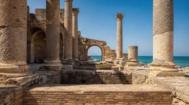
Carthage’s Antonine baths were among the largest bathing complexes in the Roman world, and keeping them supplied with water required one of the most ambitious feats of Roman engineering in Africa: an aqueduct running 132 km from the spring at the foot of Mount Zaghouan all the way to the city, one of the longest aqueducts built anywhere in the Roman empire. The water temple at Zaghouan marks the source, a semicircular nymphaeum built around the spring itself in the 2nd century AD, with a colonnaded courtyard framing the point where the aqueduct’s journey began.
What survives today is atmospheric rather than grand in scale — the temple’s curved wall and column bases remain, set into the base of the mountain with genuinely striking views over the town of Zaghouan and the plain beyond, and the spring itself still flows. Sections of the aqueduct’s arched channel survive at intervals along the historic route toward Tunis and Carthage, though it’s a broken chain of fragments rather than a continuous structure you can walk the length of.
| Where | Foot of Mount Zaghouan, about 60 km south of Tunis |
| Cost | Around 5 TND (roughly €1.50) entry at the temple |
| Time needed | 1 to 2 hours at the temple; longer if hiking the mountain |
| Getting there | Car or tour from Tunis, about 1 hour each way |
| Best time | Spring or autumn for the mountain hike; any season for the temple itself |
The water temple
The nymphaeum’s semicircular colonnade, though partially ruined, still traces a clear and elegant curve around the spring, giving a strong sense of how deliberately theatrical Roman engineers made even a purely functional structure like a water intake. Water still emerges from the spring today, feeding a modern reservoir nearby that continues to supply the region — a rare case of Roman-identified infrastructure remaining functionally relevant, even if the modern system doesn’t use the ancient channel itself.
The site sits directly against the base of Mount Zaghouan, and the backdrop matters as much as the ruins: pine-covered slopes rising sharply behind the temple, with the town of Zaghouan spread out below. It’s a genuinely scenic spot, quieter and greener than most Tunisian Roman sites, which tend to sit on open, exposed plains.
Following the aqueduct route
From the temple, the aqueduct’s original course ran north-east across the plain toward Oudhna, then on toward Tunis and Carthage, and sections of its arched masonry channel survive at various points along that route, visible from the road in places, particularly near Mohammedia and along stretches closer to the Tunis suburbs. It’s not set up as a signed heritage trail you can follow continuously — seeing the aqueduct properly means knowing roughly where the surviving arches are and stopping at them individually, which is easier with a guide or driver familiar with the route than trying to self-navigate.
For most visitors, the temple itself is the highlight and the aqueduct fragments along the drive are a bonus rather than the main event. If seeing more of the aqueduct specifically interests you, mention it to your guide or driver in advance, since the standard day-tour stops don’t always include a dedicated aqueduct-viewing stop beyond the temple source.
Climbing Mount Zaghouan
Beyond the water temple, Mount Zaghouan itself (Jebel Zaghouan) is the highest peak in the immediate Tunis region at just over 1,295 metres, and a marked trail climbs from near the temple area toward the summit through pine and juniper forest. It’s a genuine hike rather than a stroll — figure four to six hours round trip depending on fitness and how far you go — and rewards the effort with panoramic views over the Cap Bon peninsula and, on a clear day, out toward the Gulf of Tunis. This is a separate undertaking from the temple visit itself and needs proper hiking shoes, water, and ideally a local guide, since the trail isn’t consistently well marked throughout.
Most day-tour itineraries from Tunis don’t include the full mountain hike, focusing instead on the temple and the town below; travellers specifically interested in the hike should plan it as a separate, dedicated outing rather than expecting it bundled into a general Roman-sites day tour.
Getting there from Tunis
Zaghouan is around 60 km south of Tunis, about an hour’s drive via the A1 motorway. There’s no direct public transport to the temple site itself, though louages do run to Zaghouan town; from there you’d need a taxi for the final short stretch up toward the temple, which sits a few kilometres outside the town centre at the base of the mountain.
A excursion from Tunis to Oudhna and the Zaghouan aqueduct is built specifically around this history, covering the amphitheatre at Oudhna en route before reaching the water temple, and is a good option if the aqueduct engineering story is your main interest. For a broader day covering all three of the region’s Roman sites, a private Roman tour of Oudhna, Zaghouan and Thuburbo Majus adds Thuburbo Majus to the same general loop.
If you’d rather build in lunch rather than plan a separate stop, a day tour to Oudhna and Zaghouan with lunch included covers the same core route with a meal built in. For travellers wanting to extend beyond a single day and explore more of northern Tunisia around Zaghouan, a two-day northern Tunisia tour departing from Sousse, Hammamet or Tunis uses Zaghouan as one stop within a wider regional itinerary.
Zaghouan town
The town of Zaghouan itself, below the temple, has a modest but pleasant historic centre with a small kasbah and a scattering of Ottoman-era buildings, worth a short wander if you have time beyond the temple visit. It’s not a major destination in its own right, but it makes a reasonable lunch stop, with a handful of local restaurants serving straightforward Tunisian fare, generally at lower prices than you’d find in Tunis or the more touristy coastal towns.
Where Zaghouan fits in a wider trip
The water temple works best as one piece of a larger plan rather than a stand-alone objective. The Zaghouan destination page gives the broader picture of the town and its surroundings, while the Zaghouan and Thuburbo Majus day trip shows how the temple pairs with a second Roman site on the same loop. If the mountain appeals more than the ruins, the Zaghouan mountain hike guide goes into the climb on its own terms.
Travellers building a first itinerary will find the best day trips from Tunis a useful way to compare Zaghouan with other options, and the Roman sites near Tunis ranked helps decide how much time the temple deserves next to the larger archaeological sites. For a route that strings several of them together, the Roman Tunisia itinerary is the natural next read.
Connecting the temple to Carthage and Oudhna
The aqueduct only makes full sense once you have seen where it ended. The Antonine baths at Carthage are the most spectacular consumer of that water, and the wider Carthage archaeological sites guide explains how the other monuments sit around them. The Carthage destination page is a good starting point if you plan to visit both ends of the aqueduct in the same trip.
Midway along the route, the Oudhna guide covers the amphitheatre and the ruins that most Zaghouan tours stop at first, and Thuburbo Majus offers the more substantial standing remains of the three. Seeing all of these together turns a modest spring-side ruin into the start of a story that runs across the whole region.
Planning the day around the temple
Because there is little public transport to the site, it helps to read about the practical side before you commit. The guide to getting around Tunis covers the general options, the louages explained page describes how the shared taxis to Zaghouan town work, and the car hire in Tunisia guide is worth reading if you prefer to stop at the aqueduct arches on your own schedule. Anyone weighing a guided outing against independent travel can consult private vs group tours in Tunisia.
For the season, the best time to visit Tunis and the seasonal pages on Tunis in spring and Tunis in autumn help you pick comfortable weather for the mountain. If you are still deciding how long to spend in the area, how many days in Tunis and the Tunis trip planning guide put a day at Zaghouan in context.
Practical notes
The water temple site opens roughly 8:30am to 5:30pm in winter with somewhat later hours in summer, though as with the smaller regional sites, confirming current hours locally is worthwhile. Entry is inexpensive, and there’s a small parking area near the site entrance. Shade is better here than at most Tunisian Roman sites thanks to the mountain backdrop and surrounding pine trees, making it a more comfortable midday stop than the open-plain sites like Thuburbo Majus or Oudhna.
If planning the mountain hike, note that the trailhead and the temple entrance are close but distinct — check with site staff or your guide about current trail conditions and access, since maintenance and marking vary.
How the aqueduct actually worked
Roman aqueducts relied entirely on gravity, which made the 132-km route from Zaghouan to Carthage a genuinely difficult engineering problem: the water had to descend gradually and continuously across a long, gently undulating landscape without ever running uphill, requiring surveyors to plan a route with an extremely precise and consistent gradient over more than a hundred kilometres, using only period instruments.
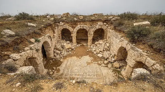
Where the terrain dipped, the aqueduct was carried on arched masonry bridges, some of which still stand today; where it crossed higher or flatter ground, the channel ran underground or at surface level, protected within a covered masonry conduit. The whole system needed to maintain flow without pumps or any mechanical assistance, purely through careful gradient calculation — a level of surveying precision that remains genuinely impressive by any era’s standards.
By the time the water reached Carthage, it fed a massive distribution system supplying both the Antonine baths and the city’s public fountains and private households, via a large cistern complex (La Malga cisterns) that stored water for distribution across the city. The Zaghouan-to-Carthage aqueduct wasn’t a single, isolated engineering feat but part of a wider network of Roman water infrastructure across the province, though it stands out as one of the longest and most ambitious single aqueduct routes anywhere in the empire.
Later history of the aqueduct and the water temple
The aqueduct fell out of active use following Carthage’s decline in late antiquity, though the water temple site itself and the surrounding area retained local significance into later periods, given the practical value of a reliable spring in a relatively dry region. Ottoman-era Tunisia saw renewed interest in the site’s water infrastructure, and elements of the historic route were periodically referenced or partially reused by later water engineers working on regional supply systems, a testament to how well the original Roman surveying had identified a genuinely good water source and route.
Modern restoration and study of the temple itself has been ongoing since the French colonial period, with the semicircular nymphaeum structure visible today reflecting significant archaeological work to stabilise and partially restore what had become an overgrown, crumbling ruin by the early 20th century.
Mistakes to avoid
Frequently asked questions about visiting Zaghouan’s water temple
How far is the aqueduct that carried water from Zaghouan to Carthage?
The aqueduct ran approximately 132 km from the spring at Zaghouan to Carthage, making it one of the longest aqueducts built anywhere in the Roman world. Sections of its arched channel survive at intervals along the historic route.
Can I see the aqueduct arches from the road?
Yes, in places, particularly near Mohammedia and at points closer to the Tunis suburbs. They’re not signposted as a formal heritage trail, so spotting them is easier with a guide or driver who knows the route than navigating independently.
Is the Jebel Zaghouan hike suitable for casual hikers?
It’s a genuine hike of four to six hours round trip through forest terrain, gaining significant elevation, so reasonable fitness and proper hiking shoes matter. It’s not a casual stroll, and the trail isn’t consistently well marked, so a local guide is advisable for anyone without hiking experience in the area.
How does Zaghouan compare to Oudhna and Thuburbo Majus for a single visit?
The three are usually combined into one loop since they sit within a compact area south of Tunis. Zaghouan offers the most scenic setting of the three thanks to the mountain backdrop; Thuburbo Majus has the more substantial standing ruins; Oudhna has the amphitheatre and is closest to Tunis.
Is there public transport to the water temple?
Louages reach Zaghouan town, but the temple sits a few kilometres outside the centre at the base of the mountain, requiring a taxi or private vehicle for the final stretch. Most visitors arrive by car or organised tour.
Does the spring still flow today?
Yes, the spring at the water temple continues to flow and feeds a modern reservoir supplying the region, though the modern water system doesn’t rely on the ancient Roman channel itself.
What’s the best season to visit?
The temple itself is pleasant year-round thanks to reasonable shade from the mountain and surrounding pines. For the summit hike specifically, spring and autumn offer the most comfortable temperatures; summer heat makes the climb considerably more demanding.
Is there anywhere to eat near the site?
Zaghouan town, a short drive from the temple, has a handful of straightforward local restaurants, generally less expensive than equivalents in Tunis or the coastal resort towns. There’s no food available at the temple site itself.
How did Roman engineers keep water flowing over 132 km without pumps?
The entire system relied on gravity, requiring an extremely precise and gradual downward gradient calculated across the whole route using period surveying instruments. Where the land dipped, the water was carried on arched masonry bridges; where the terrain allowed, it ran through underground or surface-level covered channels, maintaining continuous flow purely through careful elevation planning rather than any mechanical assistance.
Where did the water go once it reached Carthage?
It fed the La Malga cisterns, a large storage complex that distributed water across the city, supplying both the Antonine baths and public fountains as well as private households, forming the backbone of Carthage’s water infrastructure during the Roman period.
Roman & Punic site tours on GetYourGuide
Verified deep-linked GetYourGuide tours. Book through these links and we earn a small commission at no cost to you.
These are our own photographs of Tunisia, not the operator's pictures of this tour — open the tour page to see those.